The Indiana Jones in me gets a kick out of exploring abandoned civilizations, so for years I was allured by the idea of Doodletown – a Hudson Valley mountain town reclaimed by nature. I decided to combine this hike with a trek up Bald Mountain to get in some miles and elevation as the former hike is very flat. The hikes can be done separately or combined easily, as they are accessed from trailheads merely steps apart from one another. These hikes are free to access, parking is just north of Iona Island Road on 9W in the town of Stony Point, NY. There is no trail map at the site, so be sure to have a copy of the Bear Mountain State Park map at hand, and note the route to take:
 Find the blue markers of the Cornel Mine Trail across the street from the parking lot.
 As you head into the woods starting with Bald Mountain, you will see a lovely little waterfall right off the bat.
  The blue blazed CM trail is two miles up towards the summit, very well marked. It begins climbing gently through the woods, be sure to detour at the partially obscured, though nonetheless beautiful waterfall.
 Then steeply ascends through a rocky portion for the remainder of the trail.
 The CM dead ends at the red blazed Ramapo-Dunderberg where you take a right
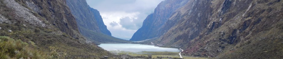
  and quickly find yourself at the gorgeous vista of the summit, although not officially marked, is extremely identifiable.
 Spy Perkins Tower at Bear Mountain State Park.
 After taking in that view, continue descending on the red trail until you reach a wide and obvious herd trail on your right. It is unmarked, but very obviously trodden.
 Take the path for 10-15 minutes until you dead end directly onto the blazed 77 trail which will lead you into Doodletown.
 You’ll begin to see ruins, stone foundations and stairs scattered along the path.
There are informational panels at certain sites.
 In the lush summertime, a lot of the paths were very overgrown. Raspberries were plentiful, which could be a reason we ran into two bear cubs on separate occasions during the hike.
 Be up to date on what to do during an encounter. I didn’t have time to take a picture, the black bears were quite close to us, but ran after I started yelling at them to do so. Dopey and adorable, our first sighting in the New York area! The wildflowers and butterflies were beautiful this time of year.
The trail dead ends once more onto the 77E take a right.

It is frequently paved, as it was an old road into town. Along the way we saw a pileated woodpecker,
 reservoir,
 and a map of the ruins in town.
 As you are nearing the end of the journey you’ll begin to hear cars. When the path splits, it’s easy enough to stay right on the unmarked trail – you are very close to the car at this point.
  As you end your hike you get an exceptional view of Iona Island.
 Then you’ll find yourself at the trailhead where the hike ends, or begins for those heading directly to Doodletown.
 Quick Notes:
Length: I would estimate 6+ mile loop
Difficulty: Moderate
Cliffnote Trail Directions: Blue (Cornell Mine)–> Right on Red (Ramapo-Dunderberg)–> Right on Herd Path–> Right on 77–> Right on 77E maintain on paved path until the road
🙂 Thanks for stopping by!
Great adventure! Thanks for sharing!