What kind of hobby requires you to wake up at 4 in the morning, drive for hours through the dark and fog, get sweaty, dirty, bruised, all scraped up, sweltering, freezing, cursing, yet somehow singing, swooning, then desperate again, and so sore you can barely lift your extremities, but so in love you forget all the rest and go back for more…again and again? Ahh mountain hiking, what is wrong with people like me to go through something like this? The Adirondack 46 are some of the best mountains in the world. Hikes like these humble you, inspire you.
I decided to tackle the MacIntyre Range on Labor Day weekend which includes three Adirondack high peaks: Algonquin, Iroquois, and Wright. To do so you must park at the Adirondack Loj [1002 Adirondack Loj Rd, Lake Placid, NY 12946]. Last Labor Day (2015), I chose to hike Mt. Marcy as my first of the ADK 46. We left quite early and got to the parking lot just before 8AM, and we were the last cars allowed in the lot. This year I wasn’t taking any chances, so when we got to the lot at 7:15 AM it was actually quiet and we had our pick of spots. This hike is only for the most experienced of hikers, who have the proper gear, more than enough water and food. We left the parking lot at 7:30 AM and our arduous journey began.
Algonquin:
The second highest peak in New York State
*Elevation: 5114’
*Ascent: 2936′
*Mileage: 10 miles round trip. This is questionable depending on what you read. The steward at the top said the trail is 5 miles to the summit, so trust him over what I see on the internet.
Begin at the far end of the parking lot on the blue trail towards Marcy Dam. Take this for .9 miles until you reach the junction for the yellow blazed Algonquin Peak – which you will remain on until the summit.
 I read from one trip review of Algonquin stating that the path gets ‘progressively rockier and steeper.’ When we were green and chipper at the beginning of the day we laughed saying, steepier and rocker as the path began to change.
 The worst thing about these ADK high peak paths are the tons of rocks that kill your feet by the end of the day. There aren’t any views initially, just quiet woods. There was a lovely trickling waterfall to look at, and we saw a mint green caterpillar, and a groggy morning toad along the way.
 Eventually we made it to the junction with Wright (which we saved for last, just to make sure we’d have energy for the farther two), you’re in the home stretch, kind of. The sign that points you towards the summit of Algonquin is chipped off, but you can see it says, 0.something.
 So less than a mile isn’t that bad. However, this is where the ‘chutes’ come into play. Long smooth stretches of rock, many of which were very wet and slippery.
 We did a lot of Gollum-ing on the way up on our hands, and crab walking on the way down on our butts. Hiking gloves would have been great to avoid scrapes and general grit. You get through that and turn around, BOOM! Adirondack beauty.
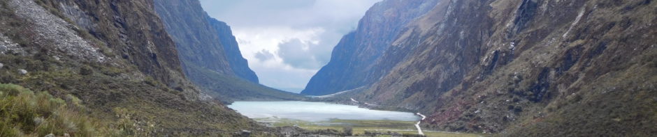
 Keep going, because once you’re out of the woods and to the base of the final stretch – you get this.
 Follow the cairns, or large rock piles, to the summit, we got there at 10AM.
 This early in the morning there were less than 10 people up there, including the steward Ryan who came over to introduce himself and answer any questions we had.
 We ate a real early lunch and took in the views for a few minutes before moving on to Iroquois in the distance.
 Iroquois:
The eighth highest peak in New York State
*Elevation: 4840’
*Ascent: 3250’
*Mileage: 1.1 mile branch from the summit of Algonquin
From Algonquin summit you can see Iroquois in the distance.
 Follow the cairns and enjoy the splendorous view along the way.
 Still quite chipper, and heading steeply downhill the scenery made me feel like I was a hobbit on an adventure. You will dead end at an arrow pointing to the left. You want to take the unmarked overgrown trail to the right. Trust me, and if you don’t trust me, check with the steward at the summit.
 So we turned and made our way through the scraggly, narrow, but clearly cut path.
 After making a serious push to summit the mountain, we were shocked and awed to find we had the place entirely to ourselves.
 It was 11AM, we tried to enjoy the view, but there is no denying what lies ahead. You can see Algonquin, which you need to re-summit heading back from the path which you just came, and Wright, looming in the near distance.
 Wright:
The sixteenth highest peak in New York State
*Elevation: 4580’
*Ascent: 2400’
*Mileage: .4 mile branch from the Algonquin trail
On the path back from Iroquois, resummiting Algonquin was just as beautiful as it was the first time around – a bit crowded now at noontime.
 We started heading down the mountain again, which is always more difficult than going up for me. It wasn’t too long before we met up with the junction to head up Wright. To me, Wright was the worst. Maybe it was because I was already exhausted from conquering two high peaks. But really, I hated the short trail up because it was all slippery exposed rock chutes.
 I was in constant fear of slipping and injuring myself so I moved very slowly. The last push seemed so steep, but it went quickly.
 Luckily, it was only a .4 mile stretch so we got up real fast regardless, and were on top of the summit by 1 PM – with incredible luck, once again all to ourselves!
 How stunning is this view? Algonquin dominates a good portion of it.
 You have the option here to look for the remnants of a US B-47 bomber which crashed on the mountain in 1962, but we were to beat to try.
 I was feeling like quite the champion, and still peppy enough to take a picture wagging six fingers around in the Michael Phelps fashion, because hey, I only have 40 mountains left to be a 46!
 Woof, that’s a lot of climbing, but I have the rest of my life. We sat for a few minutes to regain our strength, it was a grueling journey back. I’m estimating the entire hike was 13 miles, but Ryan the Summit Steward thinks the MacIntyre Range can be as long as 14 miles. Either way, my feet were destroyed from the rocks. I painfully felt each step on the way down. My knees hurt, my hips hurt, my shoulders hurt, and the last two miles were the longest. I almost thought the parking lot would never show its face, until it did. We got back to car at 3:30 – 8 hours total at a relaxed pace with lunch and a nice break on each mountain. It was a day that pushed me to my limits, but one of the best days of my life to date!